
A low pressure center is gaining strength 200 miles east of St. Augustine, Florida, and it will continue grow stronger as a tropical depression through Tuesday. It will wander around off the coast of Florida while it gathers some strength through Tuesday morning.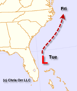
The weather environment is not very favorable for development, but as it drifts east of Georgia Tuesday night or Wednesday it may approach tropical storm strength.
The storm will remain well offshore as it continues to move northeast, drifting past Cape Hatteras, North Carolina, Thursday night and Friday with winds of 40 to 50 mph. High surf will be the greatest problem with this storm - "Arthur" if it becomes a tropical storm.
Most significantly, the tropical cyclone will help us get a read on how aggressive the National Hurricane Center will be in classifying storms this year. It will also allow us to get a glimpse at how insurance stocks like Allstate (ALL), Travelers (TRV) and Chubb (CB) will react to a tropical storm threat.
Comments
Log in or sign up to join the conversation.