
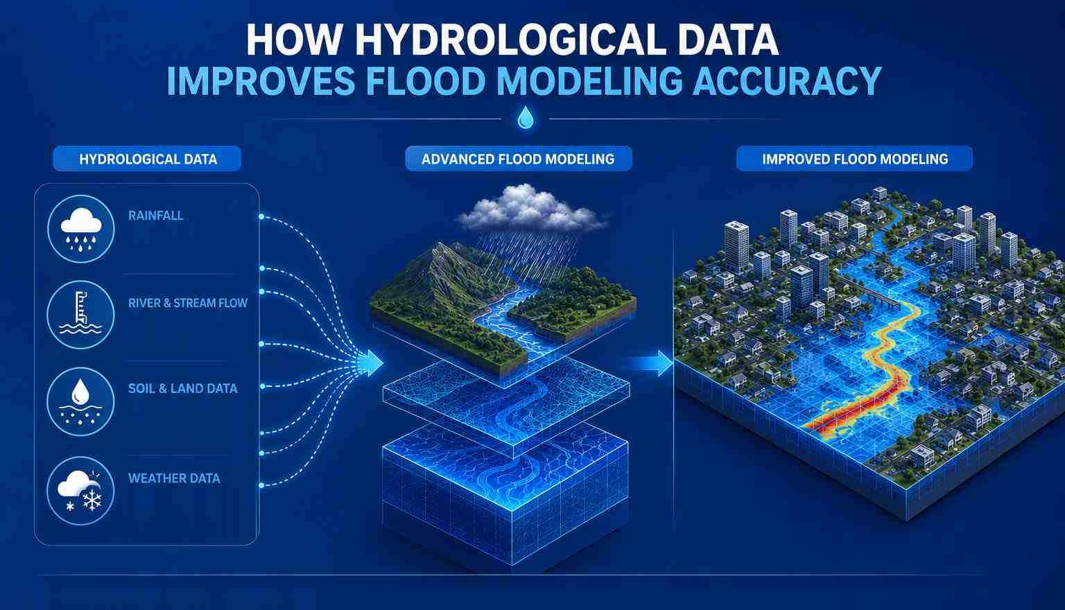
Flood modeling depends on reliable information about how water moves through a landscape. Rainfall patterns, river flow, soil conditions, elevation, drainage networks, and catchment characteristics all influence how much water reaches a particular area and how quickly it moves.
When these factors are properly assessed, flood models can provide a more realistic picture of potential flooding. This is why hydrological data plays an important role in improving flood modeling accuracy. It helps professionals understand water behaviour before developing simulations and supports better flood risk assessment, planning, and decision-making.
Understanding the Role of Hydrological Data
Hydrological data provides information about the movement, distribution, and availability of water within a particular area. For flood studies, this information can include rainfall intensity, duration, river discharge, water levels, runoff, groundwater conditions, and historical flood records.
The quality of this information directly affects the reliability of a flood model. If rainfall or streamflow information is incomplete, the model may not accurately represent how much water enters a river system or drainage network.
A detailed Hydrological Assessment helps organize and interpret this information before it is used in a flood study. It provides the foundation for understanding how a catchment responds to rainfall and changing water levels.
How Rainfall Data Supports Flood Modeling
Understanding Rainfall Intensity and Runoff
Rainfall is one of the most important inputs in flood modeling. Heavy rainfall can generate significant surface runoff, particularly when the ground cannot absorb water quickly enough.
Information about rainfall intensity, duration, frequency, and distribution helps determine how much water may enter rivers, streams, and drainage systems. Historical rainfall records can also help identify patterns associated with previous flood events.
When rainfall data is combined with information about soil, land use, elevation, and drainage, professionals can estimate how water may move through the catchment during different rainfall scenarios.
This makes rainfall information an important part of developing reliable flood simulations and improving the overall accuracy of flood predictions.
The Importance of Catchment Analysis
Understanding How Water Moves Across a Landscape
A catchment is an area where rainfall and surface runoff eventually drain toward a common water body or outlet. Understanding its characteristics is essential for accurate flood studies.
Catchment Analysis examines factors such as catchment size, slope, drainage patterns, soil characteristics, land cover, stream networks, and elevation. These factors influence how quickly rainfall becomes runoff and reaches rivers or low-lying areas.
For example, areas with steep slopes may move water more rapidly toward a drainage channel, while areas with flatter terrain may experience slower water movement and greater surface accumulation.
By studying these characteristics, flood modelers can create more representative simulations of how water behaves during heavy rainfall.
Combining Hydrological and Hydraulic Modelling
Creating a More Complete Flood Picture
Hydrological and hydraulic modeling address different parts of the flood process. Hydrological analysis focuses on how rainfall becomes runoff and how much water reaches a particular location. Hydraulic modelling examines how that water moves through rivers, channels, floodplains, drainage systems, and other areas.
Combining these approaches can produce a more detailed understanding of flood behaviour.
Hydrological inputs can provide estimated flow values, while hydraulic models can use those flows to simulate water depth, velocity, and the areas that may become inundated.
This connection is important because knowing the amount of water alone does not explain where flooding will occur. Hydraulic analysis helps translate water flow into a physical representation of potential flood conditions.
Using Historical Flood Data
Learning from Previous Flood Events
Historical flood records can provide valuable information for improving model reliability. Past events can reveal where water accumulated, how river levels changed, which areas were affected, and how quickly flooding developed.
When historical information is available, it can be compared with model outputs to identify differences between simulated and observed conditions.
This process can help professionals refine model parameters and improve future simulations. Historical records may also help identify recurring flood patterns and vulnerable locations that require closer assessment.
Reliable historical data therefore supports both model validation and broader Flood Risk Assessment.
Supporting Flood Inundation Mapping
Identifying Areas at Risk
One of the key applications of flood modeling is Flood Inundation Mapping. These maps show areas that may be affected by floodwater under particular conditions.
Hydrological data contributes to this process by helping estimate the amount of water generated during different rainfall or river-flow scenarios. Hydraulic modeling can then simulate how that water spreads across the surrounding landscape.
The resulting maps can help identify potentially affected residential areas, roads, agricultural land, public infrastructure, and other important locations.
Accurate inundation mapping can support land-use planning, emergency preparedness, drainage improvements, and flood mitigation strategies.
Improving Flood Risk Assessment
Supporting Better Planning Decisions
A reliable Flood Risk Assessment requires more than identifying whether an area has flooded in the past. It should consider the probability, intensity, extent, and potential consequences of future flood events.
Hydrological data helps improve this assessment by providing evidence about rainfall, runoff, river behaviour, and catchment response.
When combined with topographic and hydraulic information, this data can help identify areas that may face greater flood exposure. It can also support decisions related to infrastructure development, drainage planning, flood protection, and emergency response.
Better data can therefore lead to better-informed decisions and more practical flood management strategies.
Why Data Quality Matters
Reliable Inputs Lead to Better Results
Even advanced modeling techniques cannot compensate for poor-quality input data. Inaccurate rainfall measurements, incomplete river records, outdated topographic information, or incorrect catchment characteristics can affect the final model results.
For this reason, data collection and validation should be treated as important parts of the modeling process.
Professionals may need to compare information from different sources, check historical records, assess inconsistencies, and select appropriate datasets for the study area. The more representative the input data is, the more useful the resulting flood model can become.
Supporting Effective Flood Modelling Services
Turning Data into Practical Insights
Flood Modelling Services use multiple types of environmental and geographical information to understand potential flood behaviour. Hydrological data forms an important part of this process because it provides the information needed to estimate water generation and movement within a catchment.
The value of flood modeling lies not only in creating simulations but also in converting those results into information that can support practical decisions. Model outputs can help professionals evaluate flood exposure, understand potential inundation, and identify areas where mitigation measures may be required.
Conclusion
Hydrological data provides an important foundation for accurate flood modeling. Rainfall records, river discharge, runoff characteristics, catchment conditions, and historical flood information help create a more realistic understanding of how water behaves during flood events.
When combined with Hydraulic Modelling, Catchment Analysis, and flood inundation mapping, hydrological information can improve the reliability of flood studies and support stronger Flood Risk Assessment.
Bhoojal Survey uses a data-driven approach to help interpret water-related conditions and support informed flood assessment. For projects requiring detailed Flood Modelling Services, reliable hydrological information remains one of the most important factors in producing useful and practical results.
Frequently Asked Questions
1. Why is hydrological data important for flood modeling?
Hydrological data helps determine how rainfall becomes runoff and how much water may enter rivers, streams, and drainage systems. Reliable data allows flood models to represent water behaviour more accurately.
2. What types of hydrological data are used in flood modeling?
Common data includes rainfall intensity and duration, river discharge, water levels, runoff, historical flood records, and catchment characteristics. The exact data required depends on the purpose and location of the study.
3. What is the difference between hydrological and hydraulic modeling?
Hydrological modeling generally focuses on how rainfall generates runoff and water flow, while hydraulic modeling examines how that water moves through rivers, channels, floodplains, and other areas.
4. How does hydrological data support flood inundation mapping?
Hydrological data helps estimate the amount of water generated during specific rainfall or flow conditions. Hydraulic modeling can then use these estimates to simulate how the water spreads and create flood inundation maps.
5. Can historical flood data improve flood model accuracy?
Yes. Historical flood information can be compared with model results to evaluate how well the model represents actual flood conditions. This can help identify inconsistencies and improve model parameters for future simulations.
Comments
Log in or sign up to join the conversation.