
Flooding remains one of the most significant natural hazards affecting infrastructure, communities and land development. As urban areas expand and rainfall patterns become increasingly unpredictable, understanding where floodwater may travel and accumulate has become essential for effective planning.
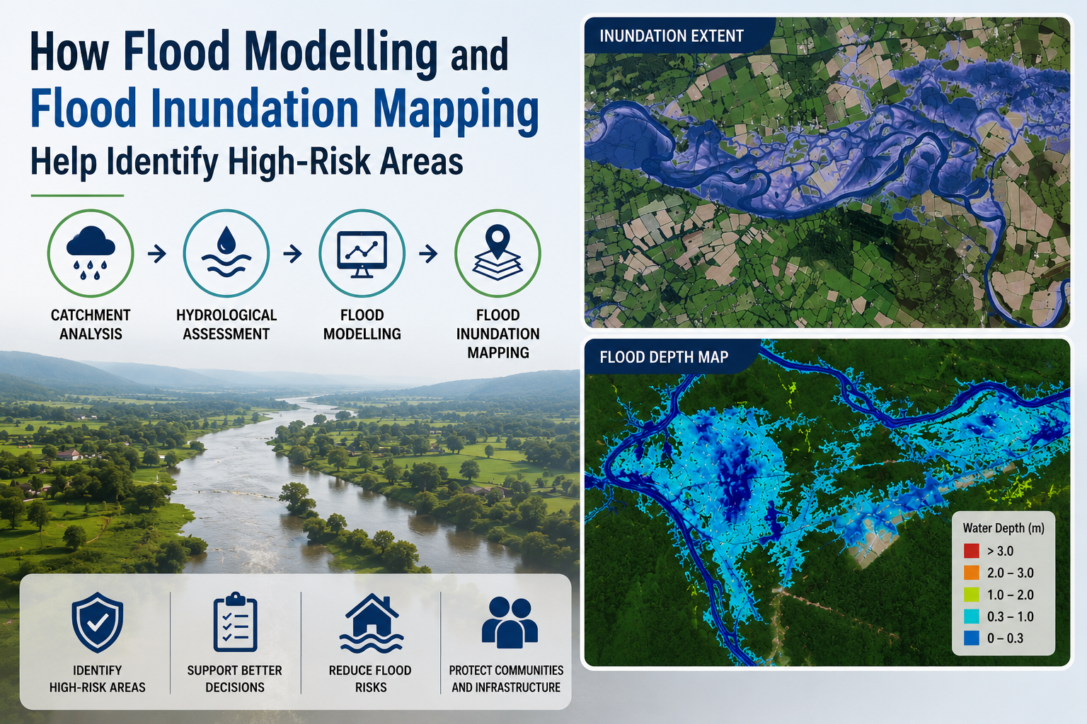
Flood modelling and flood inundation mapping provide a scientific basis for identifying areas exposed to potential flooding. By combining rainfall data, terrain information, river characteristics and catchment behaviour, these studies help assess how a flood may develop and which locations are likely to experience the greatest impact.
Understanding Flood Modelling
Flood modelling is the process of simulating how water moves through rivers, drainage systems, floodplains and surrounding landscapes during different rainfall or flow events. It uses hydrological and hydraulic data to estimate factors such as water depth, flow velocity, flood extent and the duration of inundation.
A reliable model does not simply show whether flooding may occur. It helps explain the scale and behaviour of a flood event. For example, a river may remain within its channel during moderate rainfall but overflow into nearby agricultural land or built-up areas during an extreme event.
This information is particularly valuable when planning roads, industrial facilities, solar parks, housing developments and other major infrastructure.
The Role of Catchment Analysis in Flood Risk Identification
Understanding Where Floodwater Comes From
A flood event often begins far beyond the area eventually affected. Catchment analysis examines the wider land area from which rainfall drains towards a particular river, stream or low-lying location.
Factors considered during catchment analysis may include:
Catchment size and shape
Land slope and elevation
Soil characteristics
Land use and vegetation cover
Drainage networks and watercourses
Rainfall intensity and distribution
These factors influence how quickly rainfall becomes surface runoff. A heavily urbanised catchment, for instance, may produce faster runoff because roads and buildings reduce the amount of water that can infiltrate the ground.
By understanding catchment behaviour, flood specialists can estimate the volume and timing of water entering downstream channels. This forms an important foundation for accurate flood modelling.
Hydrological Assessment: Converting Rainfall into Flood Flows
A hydrological assessment focuses on the relationship between rainfall and runoff. It helps estimate how much water may enter a river, drain or other watercourse during a specific rainfall event.
Historical rainfall records, design storms and catchment characteristics can be used to estimate peak flows for different return periods. These flows may then be applied within a flood model to assess the likely consequences.
For example, a 100-year design flood may produce a significantly larger flow than a more frequent rainfall event. Modelling both scenarios can reveal whether critical infrastructure remains protected or becomes exposed under severe conditions.
Hydrological assessment therefore helps ensure that flood risk studies are based on realistic flow estimates rather than assumptions about water behaviour.
How Flood Inundation Mapping Identifies High-Risk Areas
Visualising the Extent of Flooding
Flood inundation mapping translates modelling results into a clear geographical representation of areas likely to be affected by flooding.
Maps can show:
The extent of potential flooding
Expected water depths
Flow paths and directions
High-velocity zones
Areas exposed during different flood scenarios
This makes it easier to identify locations where floodwater may threaten people, property or infrastructure.
For instance, two areas may both fall within a floodplain, but their level of risk may differ considerably. One location may experience shallow and slow-moving water, while another may be exposed to deeper, faster flows. Flood inundation mapping helps distinguish between these conditions.
Identifying High-Risk Areas for Development and Infrastructure
The combination of flood modelling and inundation mapping supports better decision-making before construction begins.
A proposed industrial facility may appear suitable based on its existing ground conditions. However, modelling may reveal that extreme flood flows could reach the site from an upstream catchment. Similarly, a road alignment may cross a natural drainage path that becomes highly active during intense rainfall.
By identifying these risks early, project teams can consider measures such as:
Relocating Critical Infrastructure
Sensitive equipment, substations or buildings can be positioned outside areas expected to experience significant inundation.
Improving Drainage Design
Drainage structures can be designed to accommodate expected runoff and maintain natural flow paths.
Raising Site Levels
Where appropriate, finished ground levels may be adjusted to reduce exposure to floodwater.
Planning Protective Measures
Flood barriers, embankments, detention areas and other mitigation measures can be assessed based on modelled flood behaviour.
These decisions are more effective when supported by site-specific technical evidence.
The Value of Professional Flood Modelling Services
Professional flood modelling services bring together hydrology, hydraulics, topographic data and spatial analysis to provide a comprehensive understanding of flood risk.
The quality of a flood assessment depends on the accuracy of input data and the suitability of the modelling approach. Reliable studies require an understanding of local terrain, drainage conditions, rainfall patterns and project requirements.
For complex developments, modelling can also compare existing and proposed conditions. This helps determine whether a project could alter flood pathways or increase risk in surrounding areas.
Bhoojal Survey supports flood risk investigations through technical studies that combine catchment understanding, hydrological analysis and spatial mapping. This approach helps provide practical information for infrastructure planning and land development decisions.
Conclusion
Flood risk cannot be assessed by examining a single location in isolation. Flood modelling, catchment analysis and hydrological assessment help explain how water is generated, transported and distributed across a landscape. Flood inundation mapping then converts this information into a clear view of areas exposed to potential flooding.
Together, these methods help identify high-risk zones, assess the likely severity of flooding and support more informed planning decisions. For infrastructure and development projects, detailed flood modelling services can provide the technical insight needed to reduce avoidable flood exposure and design more resilient sites.
FAQs
1. What is flood modelling?
Flood modelling uses hydrological and hydraulic data to simulate how water moves through rivers, drainage systems and surrounding land during flood events.
2. What is flood inundation mapping?
Flood inundation mapping shows the geographical extent of areas likely to be affected by flooding, often including information on water depth and flow behaviour.
3. Why is catchment analysis important for flood studies?
Catchment analysis helps determine how rainfall is converted into runoff and how water reaches downstream areas, improving the accuracy of flood flow estimates.
4. What is included in a hydrological assessment?
A hydrological assessment typically examines rainfall, runoff, catchment characteristics and expected peak flows for selected flood scenarios.
5. When are flood modelling services required?
Flood modelling services are commonly required for infrastructure planning, land development, flood risk assessment, drainage design and projects located near rivers, streams or flood-prone areas.
Comments
Log in or sign up to join the conversation.